ADDENDUM
to the
FINAL ENVIRONMENTAL IMPACT REPORT/STATEMENT
Antelope-Pardee 500-kV Transmission Project
Application No. A.04-12-007
SCH No. 2005061161
ADDENDUM
to the
FINAL ENVIRONMENTAL IMPACT REPORT/STATEMENT
Antelope-Pardee 500-kV Transmission Project
Application No. A.04-12-007
SCH No. 2005061161
Table of Contents
Map provided by City of Santa Clarita . . . . . . . . . . . . . . . . . . . . . . . . . Addendum - A.1
February 14, 2007 Letter from the City of Santa Clarita. . . . . . . . . . . . . . Addendum - B.1
CPUC Letter of February 28, 2007 Responding to
Letter from City of Santa Clarita . . . . . . . . . . . . . . . . . . . . . . . . . . . . . Addendum - C.1
Analysis of Santa Clarita Alternative . . . . . . . . . . . . . . . . . . . . . . . . . . .Addendum - D.1
November 30, 2006 Letter from Southern California
Edison Company Commenting on Santa Clarita Alternative . . . . . . . . . . . .Addendum - E.1
Comments of CH2M Hill (SCE's Consultant) on Lack of Justification
For Santa Clarita Alternative Based on Visual Resources Impacts and
Accompanying Figures . . . . . . . . . . . . . . . . . . . . . . . . . . . . . . . . . . . Addendum - F.1
ADDENDUM
to the
FINAL ENVIRONMENTAL IMPACT REPORT/STATEMENT
Antelope-Pardee 500-kV Transmission Project
Application No. A.04-12-007
SCH No. 2005061161
* * * * *
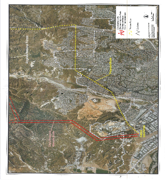
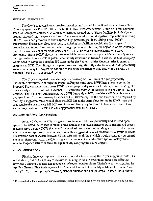
MAP
Provided by City of Santa Clarita
Showing City Boundaries, Built-Up Areas,
Route of Proposed Project Through City of Santa Clarita
and Adjacent Unincorporated Areas, and
Route of Santa Clarita Alternative Through City of Santa Clarita
and Adjacent Unincorporated Areas


ADDENDUM
to the
FINAL ENVIRONMENTAL IMPACT REPORT/STATEMENT
Antelope-Pardee 500-kV Transmission Project
Application No. A.04-12-007
SCH No. 2005061161
Analysis of the Santa Clarita Alternative
The Santa Clarita Alternative provides an alternate routing for the transmission line generally between the Angeles National Forest and the Pardee Substation. The Santa Clarita Alternative is identical to the proposed Project from the Antelope Substation to approximately Mile 18.6. From approximately Mile 18.6, the Santa Clarita Alternative would diverge from the proposed Project route by turning west rather than continuing in a southerly direction. The alternative route would continue west for approximately 1.9 miles in a new 180-foot-wide ROW, crossing an existing Los Angeles Department of Water and Power (LADWP) transmission line corridor at approximately Mile 19.4. At approximately Mile 20.6, the alternative route would meet another existing LADWP transmission corridor and continue in a northwesterly direction adjacent to that LADWP corridor. The transmission line would leave Angeles National Forest and cross San Francisquito Canyon adjacent to the LADWP corridor, and continue in a northwesterly direction for 1.6 miles. At Mile 22.1, the transmission line would turn southwest and depart from the adjacent LADWP corridor. The transmission line would proceed in a southwesterly direction for approximately 1.3 miles before turning south and continuing for approximately 1.6 miles. At Mile 25.0, the transmission line would meet an existing SCE transmission corridor consisting of two sets of single-circuit 220-kV lines. This corridor would be widened to accommodate the additional 500-kV transmission line. The new transmission line would run along the west of this corridor for approximately 1.1 miles. At Mile 26.1, the transmission line would turn south for approximately 1.0 mile, remaining parallel and west of an existing SCE 66-kV subtransmission line, entering the Pardee Substation at Mile 27.1. Features of the Santa Clarita Alternative compared to the proposed Project are presented in Table 1, below.
Table 1. Features of the Santa Clarita Alternative Compared to the Proposed Project | |||
Feature |
Description |
Santa Clarita Alternative |
Proposed Project |
Transmission Line |
Linear distance of transmission line |
27.1 miles total 27.1 miles overhead |
25.6 miles total 25.6 miles overhead |
Linear distance of existing ROW |
17.5 miles (17.5 miles to be widened) |
22.8 miles (17.5 miles to be widened) | |
Linear distance of new ROW |
9.6 miles |
2.8 miles | |
Linear distance on NFS lands |
14.0 miles (1.4 miles of new ROW adjacent to LADWP corridor) |
12.6 miles (0 miles of new ROW) | |
Estimated duration of construction |
14 months |
13 months | |
Existing 66-kV line |
To be removed from Mile 1.1 to 18.6 |
To be removed Mile 1.1 to 18.6 | |
Environmental Setting and Impact Analysis
Below is a description of the environmental setting and the potential environmental impacts associated with the Santa Clarita Alternative compared to SCE's proposed Project for issue areas where a noticeable difference could be evaluated. The conclusions in this analysis are based on preliminary evaluations of affected resources. More detailed analysis would be required to prepare definitive conclusions regarding the significance of impacts.
Biological Resources
Environmental Setting
For the Santa Clarita Alternative, a new transmission line route would be constructed north of Pardee Substation in the foothills east of the Pitchess Detention Center. This area supports rolling foothills characterized by relatively undisturbed sections of contiguous coastal sage scrub habitat, riparian scrub, and oak woodlands. Near the southern border of the ANF, the alternative would cross Pettinger Canyon, Dry Creek, and San Francisquito Creek. Habitat in this section of the ROW consists of a variety of coastal sage scrub, chaparral, oak riparian woodland, riparian woodland, disturbed areas, and non-native grasslands. At San Francisquito Creek, the transmission line would cross areas supporting rural home sites, disturbed alluvial fan scrub, and riparian scrub. Dry Canyon reservoir appears to support mature cottonwood woodland.
Impacts
Implementation of this alternative would have greater impacts to biological resources than the proposed Project, which would be largely located within existing ROWs between Mile 18.6 and the Pardee Substation. For example, this alternative would be located almost entirely in relatively undisturbed native habitat when compared to the existing more urbanized ROW in the City of Santa Clarita, which is characterized by a narrow band of coastal sage scrub habitat bordered by residential development. As such, greater temporary and permanent loss of native vegetation communities would be anticipated for the Santa Clarita Alternative compared to the proposed Project (Impact B-1)1; although impacts could be reduced to a less-than-significant level with implementation of Mitigation Measures B-1a (Provide Restoration/Compensation for Impacts to Native Vegetation Communities), B-1b (No Activities will occur in Riparian Conservation Areas), and R-4 (Permanent Closure and Re-vegetation of Construction Roads).
Large sections of contiguous open space, greater than one mile in width in many locations, would be crossed with this alternative. When compared to the existing ROW, plant communities in the re-routed portion of this alternative have a greater potential to support sensitive plants (Impact B-7)2 and wildlife (Impact B-3)3 based on the lack of disturbance, variety of structurally diverse habitat types, available prey base, and connectivity to open space. However, impacts to sensitive plants and wildlife could be minimized with implementation of Mitigation Measures B-7 (Conduct Surveys for Sensitive Plant Species) and B-1a (Provide Restoration/Compensation for Impacts to Native Vegetation Communities), respectively (Class II). Construction activities and increased vehicular traffic through these undeveloped areas would also have greater potential to disturb wildlife species than the proposed Project by interfering with breeding or foraging activities, altering movement patterns, or causing animals to temporarily avoid areas adjacent to the construction zone (Impact B-5)4. Except where undeveloped wildlife habitats are known to support rare, threatened, or endangered species, or nesting birds, impacts on wildlife from construction would generate potentially adverse but less-than-significant impacts (Class III).
The Santa Clarita Alternative also has greater potential than SCE's proposed Project to be utilized as a wildlife corridor. The area from Castaic Creek through Tapia Canyon to San Francisquito Creek and along NFS lands (Impact B-29)5 supports broad sections of open space and riparian corridors. Unlike the proposed Project where existing access roads have generally been established along the alignment, the Santa Clarita Alternative would require the development of new access and spur roads. Vehicle traffic associated with both construction and maintenance activities may impede wildlife movement along this corridor. Because these activities would be temporary or intermittent, the increase in traffic would not completely impede the movement of wildlife and would not affect the nocturnal movement of wildlife; therefore, this impact would be considered less than significant with no mitigation required (Class III).
The Santa Clarita Alternative has the potential to result in greater impacts to sensitive species than SCE's proposed Project, which is generally located in an existing ROW for the equivalent portion of the route. As discussed in the environmental setting above, this alternative would traverse relatively undisturbed sections of contiguous coastal sage scrub habitat, riparian scrub, and oak woodlands. Coastal California gnatcatchers have a limited potential to occur in coastal sage scrub habitat, and as such this alternative would have a greater potential to impact this species (Impact B-12)6 than the proposed Project. Gnatcatchers, if present in or adjacent to the ROW, could be directly impacted by construction activities through removal of nests and habitat. Construction noise, dust, and the presence of project personnel could also result in the disruption of breeding or nursery behavior such as incubating or attending the nest. Because of the potential for this species to be present in the proposed ROW, focused surveys for coastal California gnatcatchers would be required by Mitigation Measure B-12 (Conduct Protocol Surveys for California Gnatcatchers), in addition to APM BIO-1, which requires pre-construction surveys for all sensitive species with the potential to occur along the ROW. If gnatcatchers are determined to be present within or adjacent to the proposed ROW, then any impacts to coastal sage scrub would be considered significant. To reduce impacts to coastal sage scrub habitat, SCE would require the presence of a biological monitor during construction (APM BIO-5) and implementation of BMPs to minimize dust and runoff (APM BIO-4) in coastal sage scrub habitat. Impacts to coastal California gnatcatchers (Impact B-12) would be reduced to a less-than-significant level (Class II) with the implementation of Mitigation Measure B-12 (Conduct Protocol Surveys for California Gnatcatchers), in addition to APMs BIO-1, BIO-4, and BIO-5 to ensure that coastal California gnatcatchers and their habitat are not significantly affected by the Santa Clarita Alternative.
There is one potential benefit to biological resources that may occur from this alternative. Although not identified in the existing ROW, arroyo toads have the potential to occur in one portion of the existing ROW at San Francisquito Creek. Construction of the Santa Clarita Alternative would avoid this area and cross the creek approximately three miles upstream in an area currently subject to heavy use from vehicle crossings. While it is not known if this species occurs in the upstream portion of creek; crossing at this location could avoid impacts to this species if present (Impact B-8)7. However, it is important to note that until the Santa Clarita Alternative has been surveyed, the presence of arroyo toad cannot be ruled out for other sections of the route.
Based on the disparity of existing biological conditions of the two routes, there would not be a reduction in impacts with the implementation of the Santa Clarita Alternative and the alternative would instead be more likely to result in adverse impacts to biological resources. In addition, until biological surveys of the proposed alternative route have been conducted, it is not possible to fully evaluate potential impacts to biological resources at this time.
Cultural Resources
Environmental Setting
An in-person records search for the re-routed portion of the Santa Clarita Alternative was completed at the South Central Coastal Information Center (SCCIC) at California State University, Fullerton, in November 2006. The records search provided information about previously recorded cultural resources and previous surveys within one-quarter mile of the alternative route. The City of Santa Clarita historical list was also reviewed.
A total of nine surveys have been conducted within a quarter mile of the alternative route. Of these, seven surveys overlie or cross the 230-foot wide proposed Area of Potential Effect (APE). The surveys covered only a small portion of the area along the alternative route.
Impacts
There are six previously recorded cultural resources and two isolated prehistoric artifacts in or within one-quarter mile of the alternative route APE (Table 2). Four of the six cultural resources are within the alternative route APE. All resources are from the historic period. One cultural resource (19-120077) near the Pardee Substation was previously identified during the survey for the proposed Project route. It was likely a historic period ranch or farmstead, but little other than a row of trees remains. It was assessed in the EIR/EIS as lacking integrity and as ineligible. Two transmission lines cross the re-routed portion of the Santa Clarita Alternative APE (P-19-186857 and CA-LAN-2132H). These transmission lines also cross or follow the proposed Project route. CA-LAN-2132H is the LADWP transmission line. It crosses the alternative route in the ANF, but would not be affected by construction of the alternative route transmission line. P19-186857 is the SCE PS 74 transmission line that would be demolished by construction of the Project. The east end of the alternative re-route connects with the P19-186857 route (Impact C-2)8. Mitigation Measure C-2 for P19-186857 requires evaluation using NRHP eligibility criteria and, if eligible, documentation as mitigation. The other resources include a homestead site with foundations and artifacts (CA-LAN-1447H), a sparse historic artifact scatter (CA-LAN-2072H), and a large mining site with mining excavations, structures, and artifacts (P19-003081). The mining site is in the ANF and crosses the entire half-mile wide records search area for the alternative route and might be difficult to avoid during construction.
No cultural resources within the APE have been listed on the California State Historic Resources Inventory, the National Register of Historic Places, the California Register of Historical Resources, the California Historical Landmarks, or the California Points of Historical Interest.
Historic maps were reviewed to determine whether historical structures may be present. The 1941 USGS Santa Susana 15 minute quad indicates one building (probably a house) on the east side of San Francisquito Canyon, where the Santa Clarita Alternative crosses into the ANF. This building is not shown on the current USGS Newhall quad, indicating it has been demolished. However, there could be an historical archaeological site at this location. The 1903 Santa Susana USGS 15 minute quad shows a building in Tapia Canyon along the alternative route near the location of CA-LAN-1447H. This may be the house (no longer extant) that was part of the homestead site recorded as CA-LAN-1447H.
The City of Santa Clarita lists 33 historical resources in its General Plan (City of Santa Clarita, 1991). Of these, 29 are in Newhall and, therefore, not near the Santa Clarita Alternative route APE. Of the remaining four resources, one is near the confluence of the Santa Clara River and Castaic Creek, one is in Placerita Canyon, one is in Soledad Canyon, and one is in San Francisquito Canyon. None of these are within one-quarter mile of the alternative route APE. Although the alternative route crosses San Francisquito Canyon, the historical resource in the canyon is the site of the St. Francis Dam disaster which is about four miles north of where the alternative route crosses San Francisquito Canyon. The County of Los Angeles does not have a register of historical resources.
The records search results indicate that there is a low potential for prehistoric sites in the Santa Clarita alternative route APE and a moderate potential for historic sites. It should be noted, however, that this assessment is based on a very small previously surveyed sample.
Table 2. Previously Recorded Cultural Resources Within One-Quarter Mile of the Santa Clarita Alternative APE. | |||||
Trinomial or Primary Record # |
Historic/Prehistoric |
Description |
In ANF |
In APE |
Recorded by |
P19-003081 |
Historic (early 20th century) |
Mining excavations, structures, and artifacts |
Yes |
Yes |
Vance & Milburn DPR Record (2001) |
P19-186857 |
Historic (1930s) |
SCE Antelope PS 74 transmission line |
Yes |
Yes |
Romani DPR Record (2002) |
CA-LAN-2132H |
Historic (1917) |
LADPW Transmission Line |
Yes |
Yes |
Macko DPR Record (1992) |
CA-LAN-1447H |
Historic (early 20th century) |
Homestead structural remains and artifacts |
No |
Yes |
Parr DPR Record (1988) |
19-120077 |
Historic |
Tree lines possibly representing a destroyed homestead site |
No |
No |
Ahmet DPR Record (2005) |
CA-LAN-2072H |
Historic |
Sparse refuse scatter |
No |
No |
Rasson DPR Record (1992) |
P19-100480 |
Prehistoric |
Isolated Artifact: Quartz chopper |
Yes |
Yes |
Vance & Milburn DPR Record (2001) |
P19-100481 |
Prehistoric |
Isolated Artifact: Andesite core |
Yes |
Yes |
Vance & Milburn DPR Record (2001) |
The survey data for the proposed Project along the portion through Santa Clarita shows that it would affect two historical archaeological sites, CA-LAN-3131 and CA-LAN-3132. The records search data for the Santa Clarita Alternative shows that it would affect two historical archaeological sites, CA-LAN-1447H and P19-003081. Because only a small portion of the Santa Clarita Alternative has been field surveyed, it is likely that more sites would be identified along this route alternative once it is completely surveyed. Thus, the Santa Clarita Alternative will likely affect more cultural resources than the proposed Project route.
Geology, Soils, and Paleontology
Environmental Setting
This alternative is located in the same geologic setting as the equivalent portion of the proposed Project. The same geologic units are exposed along this alternative, consisting of the Mint Canyon Formation, the Castaic Formation, the Saugus Formation, alluvium, and active stream channel deposits. Soil units encountered along this alignment have the same characteristics as those encountered along the equivalent section of the proposed Project alignment.
Impacts
Compared to SCE's proposed Project, landslide hazards along this alignment are higher from approximately Mile 18.6 to Mile 22.5 where this alternative crosses hills and valleys with many mapped small and moderate sized landslides, primarily in the Saugus and Castaic Formations. The south-trending portion of this alignment, from approximately Mile 22.5 to the Pardee Substation, does not cross through any areas identified with existing landslides, although it is underlain primarily by the landslide prone Castaic Formation. As with the proposed Project, unmapped landslides and areas of localized slope instability may also be encountered in the hills traversed by the alignment. As such, the Santa Clarita Alternative is likely to have greater potential to cause slope instability during excavation and grading (Impact G-1)9 and greater potential for the transmission line to be damaged by landslides, earth flows, and debris slides (Impacts G-9)10. Similar to the proposed Project, implementation of Mitigation Measures G-1 (Protect Against Slope Instability) and G-9 (Geotechnical Surveys for Landslides) would reduce these impacts to a less-than-significant level (Class II). The seismic setting is the same as for the proposed Project, and is subject to similar impacts from fault rupture, seismic groundshaking and earthquake induced landslides, although landslide potential would be greater due to crossing a higher landslide prone area (see Impact G-1, above). As with the proposed Project this alternative crosses the San Gabriel fault, and although the section of the fault crossed by this alternative is not Alquist-Priolo zoned it is still considered active and the alignment could potentially be damaged by fault rupture (Impact G-4)11. Implementation of Mitigation Measure G-4 (Minimize Project Structures within Active Fault Zones) would reduce this impact to a less-than-significant level (Class II). This alternative would also be subject to potential liquefaction related phenomena (Impact G-5)12; however, it crosses less liquefiable material (alluvial deposits) along its alignment, therefore slightly reducing the risk of damage to project structures from liquefaction. Mitigation Measure G-5 (Geotechnical Investigations for Liquefaction and Slope Stability) would reduce this impact to a less-than-significant level (Class II).
More new access roads would be required for the Santa Clarita Alternative due to the more remote location and miles of new ROW to be established, resulting in greater potential to permanently alter topography (Impact G-3)13. As only limited shallow grading for access roads and work areas is anticipated and excavations are limited to the tower footing areas, substantial alterations in topography are not anticipated and impacts would be less than significant (Class III).
The potential for encountering significant fossils during excavation for this alternative would be the same as for the equivalent portion of the proposed Project, as it crosses the same geologic units with high paleontologic sensitivity, the Mint Canyon, the Saugus, and the Castaic formations, which all are known to contain significant fossils (Impact G-10)14. Mitigation Measure G-10 (Protection of Paleontological Resources) would reduce impacts to unique or significant fossils to a less-than-significant level (Class II).
Hydrology and Water Quality
Environmental Setting
South of Mile 18.6, major overhead water body crossings for the proposed Project would include Pettinger Canyon, Haskell Canyon, and San Francisquito Canyon. The Santa Clarita Alternative south of Mile 18.6 would cross Pettinger Canyon, Dry Creek, San Francisquito Creek, Tapia Canyon, and Wayside Canyon.
Impacts
A total of five minor mountain stream or valley wash crossings would occur for the proposed Project within Santa Clarita, whereas the re-routed portion of the Santa Clarita Alternative would cross seven streams due to the additional hilly/mountainous terrain traversed by this alternative. These additional crossings would increase the potential for construction activities to degrade water quality, both resulting from soil erosion and sedimentation caused by construction activities (Impact H-1)15, which would also be potentially greater in steep terrain, and from accidental release of potentially harmful materials during construction activities (Impact H-2)16. Mitigation Measures H-1a (Implementation of Erosion and Sediment Best Management Practices), H-1b (Maximum Road Gradient), H-1c (Road Surface Treatment), H-1d (Timing of Construction Activities), H-1e (Dispersion of Subsurface Drainage from Slope Construction Areas), H-1f (Control of Side-cast material, Right-of Way Debris and Roadway Debris) would reduce water quality impacts soil erosion and sedimentation to a less-than-significant level (Class II). APMs HYD-4 through HYD-6 as well as Mitigation Measures PH-1a (Environmental Training and Monitoring Program), PH-1b (Hazardous Substance Control and Emergency Response Plan), PH-1c (Proper Disposal of Construction Waste), and PH-1d (Emergency Spill Supplies and Equipment) would reduce the potential impact of accidentally spilled materials on water quality to a less-than-significant level (Class II).
Land Use and Public Recreation
Environmental Setting
The Santa Clarita Alternative would deviate from SCE's proposed Project from Mile 18.6 on NFS lands in the ANF, until it terminates at Pardee Substation at Mile 27.1 within the City of Santa Clarita. Generally, this alternative would traverse NFS land and vacant private land along its route. The route would traverse private land designated by Los Angeles County and the City of Santa Clarita for the following types of uses: Single Family Residential and Agriculture as it crosses San Francisquito Creek; Open Space and Recreation where it traverses proposed residential developments, and Utility and Commercial Facilities and Extraction (facilities or operations) near the southern end of the route. The area traversed by the Santa Clarita Alternative consists mostly of uninhabited and steep terrain within the ANF and the unincorporated areas of Los Angeles County. Within the City of Santa Clarita, existing land uses are largely industrial in nature.
Specifically within the ANF, the route would cross NFS lands designated as Backcountry Zone and private in-holdings (non-NFS lands), including LADWP property and a few vacant parcels. After exiting the ANF, the Santa Clarita Alternative would travel northwest adjacent to two single-family residences before entering and paralleling the northwest corner of the Tesoro del Valle development (TR 51644) with proposed 2,500 residential units. Although construction is currently ongoing in the southern end of the Tesoro del Valle development, portions to the north are currently undeveloped. Once exiting the Tesoro del Valle development, the transmission line would cross one vacant parcel before turning southwest at the ANF border. At this point the line would transverse approximately 5 vacant parcels, including the northernmost point of proposed Tract Map 53822, which is a proposed 405-home residential development referred to as the Tapia Ranch project. The line would continue into the center of the TR 53822 before turning south, bisecting this proposed tract. The transmission line would exit TR 53822 and continue south through the western portion of Tesoro del Valle, crossing designated open space. Once exiting the residential development, the line would continue south across Los Angeles County-owned land before entering an existing SCE transmission line corridor, consisting of two sets of single-circuit 220-kV lines. The corridor would need to be widened to accommodate the additional 500-kV transmission line. The new transmission line would run parallel and west of this corridor for approximately 1.1 miles passing the Peter J. Pitchess Detention Center to the northwest, and the Rye Canyon Business Park and a former Lockheed R&D facility to the southeast. At this point, the transmission line would turn south for approximately 1.0 mile, parallel and west of an existing SCE 66-kV subtransmission line, terminating at the Pardee Substation.
The portion of the Santa Clarita Alternative south of Mile 18.6 would not traverse any known or proposed parks or bike routes. It would potentially traverse the Castaic Creek and the Cliffie Stone/San Francisquito Canyon Trails. The Castaic Creek Trail is a State trail running east-west in unincorporated Los Angeles County near the boundary with Angeles National Forest west of San Francisquito Canyon. The Castaic Creek Trail intersects with the northern portion of Los Angeles County's proposed Cliffie Stone/San Francisquito Canyon Trail that runs north-south along San Francisquito Creek. It is unknown whether the Cliffie Stone/San Francisquito Canyon Trail is a completed or proposed trail at this time. In addition, the route would likely traverse land designated as open space and recreation within the Tesoro Del Valle development, however at this time the purpose and status of these lands are unknown. The route would not affect any established recreational resources with the ANF.
The Alternative would traverse land designated as Grazing Land on the east and west sides of San Francisquito Creek and in the southern portion of the route. The route may traverse a horse ranch or other agricultural area in the vicinity of San Fancisquito Creek; however, there are no parcels designated as Prime Farmland or with Williamson Act contracts along the route.
Other issues that characterize the area from a land use perspective include the existence of various mineral resources. The Pardee Substation is located within Mineral Resource Zone 2 (MRZ-2), which contains construction-grade aggregate. In addition, the route would traverse known and potential oil and natural gas extraction areas, as well as various producing, idle, and abandoned oil and natural gas wells just north of the City of Santa Clarita city limits south to Pardee Substation. Specifically, there is a natural gas or petroleum facility that would be located adjacent to the west of the route just north of Pardee Substation. There is also unknown liquid or solid waste disposal facility that may be associated with the Detention Center. The Castaic Conduct, a pipeline owned by the Castaic Lake Water Agency (CLWA) that is used to deliver water to purveyors, would cross the proposed route from northwest to southeast just as the route turns southwest through the SCE transmission corridor.
Impacts
South of Mile 18.6, where it diverges from SCE's proposed Project route, the Santa Clarita Alternative would generally traverse undeveloped areas in the City of Santa Clarita, unincorporated Los Angeles County, and the ANF. As such, this alternative would result in fewer short-term construction-related impacts to existing residential and commercial land uses (Impact L-1)17 than the proposed Project, as it would be located adjacent to fewer of these land uses. Impacts would be reduced to a less-than-significant level with application of Mitigation Measures N-1a (Nighttime Construction Noise Restriction in Santa Clarita), N-1b (Provide Advanced Notification of Construction), and N-1c (Provide Shields for Stationary Construction Equipment). Long-term impacts to fewer commercial land uses would occur (Impact L-4)18, as fewer commercial land uses are located along the route. Specifically, the re-route would avoid the Veluzat Motion Picture Ranch, which would reduce long-term impacts to commercial land uses to a less-than-significant (Class III) compared to the proposed Project. (Note: Impacts to Veluzat Motion Picture Ranch are also avoided by Alternative 4, which has been recommended for approval by the CPUC.)
Similar to SCE's proposed Project, the Santa Clarita Alternative would affect planned land uses, such as Tract 53822, but would avoid the proposed MacMillan Meadow Peak project near Haskell Canyon that would be affected by the proposed Project. (Note: Impacts to the MacMillan Meadow Peak project are also avoided by Alternative 4, which has been recommended for approval by the CPUC.)
The Santa Clarita Alternative would potentially traverse several Los Angeles County trails, including the Castaic Creek and the Cliffie Stone/San Francisquito Canyon Trails, as well as land designated as open space and recreation within the Tesoro Del Valle development; however, this alternative would avoid impacts to Chesebrough County Park, Mountainview Park, and a proposed bicycle trail associated with the proposed Project (and Alternative 4). Construction of the Santa Clarita Alternative would potentially preclude or interrupt the use of these trails and open space areas to ensure public safety during construction. Short-term preclusion of these facilities would adversely impact the adjacent residences and other community members who use these facilities (Impact R-1)19. To reduce significant construction impacts to recreational users, the following mitigation measures have been identified: Mitigation Measures R-1a (Coordinate Construction Schedule with the Authorized Officer for the Recreation Area), R-1b (Identify Alternative Recreation Areas), R-1c (Temporary Closure of Off-Highway Vehicle Routes During Construction), and R-1d (Temporary Upgrades to Forest System Roads), as well as Mitigation Measure B-1a (Provide Restoration/Compensation for Impacts to Native Vegetation Communities). These mitigation measures would minimize construction impacts to recreationists and recreational sites. The implementation of these mitigation measures would reduce construction impacts to less-than-significant levels (Class II).
Noise
Environmental Setting
Unlike the proposed Project, which would traverse through existing residential development in the City of Santa Clarita, including passing in proximity to Mountain View Elementary School (Mile 21.7), Chesebrough County Park (Mile 23.2), North Park Elementary School (Mile 23.2), Rio Norte Junior High School (Mile 24.0), traversing through Mountain View Park (Mile 22.1), as well as passing by many homes located adjacent to the route, the Santa Clarita Alternative would place the new transmission line in an area of Santa Clarita with few existing sensitive receptors. For the portion of this alternative that deviates from SCE's proposed Project, sensitive receptors would be limited to a few commercial buildings located north of the Pardee Substation, along Johnson Parkway, and residences located along San Francisquito Canyon Road. The alternative route would also avoid the Veluzat Motion Picture Ranch.
Impacts
For the portion of the Santa Clarita Alternative that deviates from SCE's proposed Project, impacts would generally be the same as the proposed Project, except that fewer sensitive receptors within Santa Clarita would be impacted. However, overall construction noise impacts associated with mobile construction equipment would occur over a longer period of time as a result of this alternative being 1.5 miles longer than the proposed project and requiring more new ROW resulting in the need to build (and maintain) more access and spur roads.
Unlike the proposed Project, the Santa Clarita Alternative would avoid the Veluzat Motion Picture Ranch (located between proposed Project Mile 19.5 to 20.3). As such, this alternative would not result in corona noise levels that would exceed the Los Angeles County standard for noise-sensitive areas (Impact N-2)20, or result in a permanent increase in ambient noise levels at the ranch (Impact N-5)21, or result in temporary increases in ambient noise levels that would severely disrupt operations at the ranch (Impact N-7)22. Alternatively, the proposed Project would result in a significant and unavoidable impact (Class I) to the ranch for all impacts associated with the Veluzat Motion Picture Ranch (Impacts N-2, N-5, and N-7). (Note: Impacts to Veluzat Motion Picture Ranch are also avoided by Alternative 4, which has been recommended for approval by the CPUC.)
For noise-related impacts, the Santa Clarita Alternative is an improvement over the proposed Project; however, Project-related noise impacts are all either short-term in nature or less than significant.
Public Health and Safety
Environmental Setting
Where this alternative deviates from SCE's proposed Project, it crosses through primarily undeveloped hill and valley terrain and the eastern ends of both the active Honor Rancho gas field and the active Wayside Canyon oil field. The Honor Rancho field in the project vicinity is primarily used for gas storage by SoCal Gas and is dotted with many gas injection wells and a few idle and abandoned oil wells. The Wayside Canyon field is an old field that has been revitalized and is being pumped with new techniques in the project vicinity and is dotted with active oil and gas wells and a few old abandoned wells. A brief review of online environmental databases (DTSC EnviroStor - www.envirostor.dtsc.ca.gov and SWRCB Geotracker - www.geotracker.swrcb.ca.gov) indicates no known contaminated sites are present along this alternative alignment.
Impacts
Impacts along this alternative would generally be the same as for SCE's proposed Project, except where the alternative alignment crosses through active portions of the Hondo Rancho and Wayside Canyon oil and gas fields. This alignment crosses in close proximity to areas historically and currently used oil and gas extraction. Excavation for tower foundations and grading for access roads could potentially encounter petroleum contaminated soil due to preexisting soil or groundwater contamination (Impact PH-2)23 and/or previously unknown spills or improper disposal of drilling wastes (Impact PH-3)24. Additional hazards in the oil fields also include encountering unknown abandoned or improperly abandoned oil/gas wells during excavation.
Based on these impacts, this alternative has a greater potential to encounter unknown hazardous materials and added hazards related to abandoned oil wells. Implementation of Mitigation Measures PH-2 (Conduct Phase II Investigations) and PH-3 (Observe Exposed Soil) would reduce the potential impacts to a less-than-significant level (Class II).
As discussed above for Hydrology and Water Quality, the Santa Clarita Alternative would cross a greater number of streams than the proposed Project. As a result, there would be greater potential for construction activities to result in groundwater contamination due to improper handling and/or storage of hazardous materials (Impact PH-1)25. Mitigation Measures PH-1a (Environmental Training and Monitoring Program), PH-1b (Hazardous Substance Control and Emergency Response Plan), PH-1c (Proper Disposal of Construction Waste), and PH-1d (Emergency Spills Supplies and Equipment) would be implemented to adequately ensure that the potential impacts would be reduced to a less-than-significant level (Class II).
Visual Resources
Environmental Setting
It is assumed for this analysis that the Santa Clarita Alternative would construct and operate a 500-kV transmission line on single-circuit lattice steel towers from Mile 18.6 to 27.1, as compared to the proposed Project with its taller, wider, double-circuit lattice steel towers from Mile 18.6 to 25.6.
Impacts
The visual impacts of the Santa Clarita Alternative would be identical to those described for the proposed Project from Mile 0.0 to 18.6. However, from Mile 18.6 to the Pardee Substation at Mile 27.1, the Santa Clarita Alternative would result in no change in existing visual conditions as seen from the Veluzat Motion Picture Ranch (Impact V-9; KOP 9)26; North High Ridge Drive (Impact V-10; KOP 10)27; Mountain View ark (Impact V-11; KOP 11)28; Rio Norte Junior High School (Impact V-12; KOP 12)29; North Park Elementary School and Chesebrough Park (Impact V-13; KOP 13)30; and all other vantage points in between these KOPs. Under the Santa Clarita Alternative, a noticeable visual change would be seen from Copper Hill Road (Impact V-14; KOP 14)31, and it is predicted that this change would be less than significant, but adverse (Class III).
From Mile 18.6 to approximately Mile 20.5, the Santa Clarita Alternative would be located in remote, generally inaccessible areas at the southern boundary of the Angeles National Forest, Santa Clara/Mojave Rivers Ranger District. According to Forest Service personnel at the District, there are no recreation trails or existing/planned developed sites in the vicinity of this alternative route. Locked gates at the ANF boundary prevent vehicular access to this portion of the ANF.
At approximately Mile 20.75, the Santa Clarita Alternative would cross San Francisquito Canyon Road and the riverbed of San Francisquito Canyon. At this location, in addition to the travelers on this high use road (as described for the proposed Project), there are many large-acreage, equestrian, single-family residences developed along the road and river. It is expected that people living in these residences are sensitive receptors who would be concerned about visual resource impacts of the Project if the Santa Clarita Alternative were constructed (high sensitivity). The new transmission line would be visible and very noticeable for approximately one-half mile on either side of the road (for a total length of one-mile), making this a foreground viewing distance from approximately Mile 20.25 to 21.25.
Because there are two existing high-voltage transmission lines that the Project would parallel, the addition of a third line would increase structural prominence and could create unnecessary visual complexity associated with asynchronous conductor spans. Implementation of a visual mitigation measure to reduce visual complexity as seen from sensitive receptor locations, by matching existing structure spacing and spans as closely as possible, would avoid this problem and reduce the visual impact. It is predicted that the resulting visual impacts would be similar to those described for Alternative 3 at KOP 10 - North High Ridge Drive (see discussion at Section C.15.8, Impact V-10). Implementation of Mitigation Measures V-1a (Use Tubular Steel Poles), V-1b (Construct, Operate, and Maintain with Existing Access Roads), V-1c (Dispose of Cleared Vegetation), V-1d (Dispose of Excavated Materials), and V-1e (Treat Surfaces with Appropriate Colors, Textures, and Finishes) would reduce visual impacts for the Santa Clarita Alternative. The resulting visual impact would be significant, but mitigable to a less-than-significant level (Class II).
From approximately Mile 21.25 to 24.9, the Santa Clarita Alternative would be completely screened by topography from all sensitive receptor locations. This alternative is not visible from single-family residential developments along the west side of San Francisquito Canyon and north of Copper Hill Drive (e.g., Casa Luna Place or Calle Lumina Drive).
From approximately Mile 24.9 to 27.1, this alternative would cross rolling foothills that would provide some topographic screening. Sensitive receptors are located on Copper Hill Drive (see Impact V-14; KOP 14), at the Mann Biomedical Park on Rye Canyon Loop, and at new commercial/professional developments along Alta Vista Avenue, Hercules Drive, Constellation, and Kelly Johnson Parkway. The Santa Clarita Alternative would also be visible from the WalMart parking lot. This alternative would cross over the new extension of Newhall Ranch Road that is currently under construction. This alternative would be visible from the intersection of Avenue Crocker and Avenue Hall, but duration of view would be short. This alternative also would be visible from the Pitchess Detention Center. Because of partial topographic screening and existing transmission lines that are visible against the skyline in this vicinity, the visual effects of this alternative are predicted to be significant, but mitigable (Class II).
Therefore, considering the topographic screening and fewer encounters of sensitive receptors, for visual resources reasons, the Santa Clarita Alternative would provide an improvement over SCE's proposed Project from Mile 18.6 to 27.1. It is important to note that the visual impacts in Santa Clarita from SCE's proposed Project result only from the replacement of existing towers with taller towers, and that incremental change in tower height is the basis for the adverse visual impacts caused by SCE's proposed Project. This differs from the visual impacts of the Santa Clarita Alternative, which are caused primarily by the introduction of a new transmission line across a natural landscape where transmission lines do not currently exist. Therefore, the increment of adverse visual change in the environment associated with the Santa Clarita Alternatives is greater than that of SCE's proposed Project.
Summary
Table 2 provides a summary of the environmental advantages and disadvantages of the Santa Clarita Alternative compared to the proposed Project, specifically focusing on the portion of this alternative that deviates from the proposed Project.
Table 2. Summary of Environmental Advantages and Disadvantages of the Santa Clarita Alternative | |
Issue Area |
Environmental Advantages/Disadvantages Compared to SCE's Proposed Project |
Biological Resources |
Advantages · May avoid impacts to arroyo toads if suitable habitat is absent at upstream crossing of San Francisquito Creek and areas of Pettinger Canyon Disadvantages · Greater impact to undisturbed coastal sage scrub and potential to impact California gnatcatchers · Greater impact to native vegetation communities · Greater potential to impact sensitive plants and wildlife · Larger number of creeks and drainages crossed · Increase potential to impact wildlife movement corridors |
Cultural Resources |
Advantages · Avoids historical archaeological sites CA-LAN-3131 and CA-LAN-3132 Disadvantages · Potential to impact a greater number of cultural resources, beyond those identified only through record searches (CA-LAN-1447H and P19-003081) |
Geology, Soils, and Paleontology |
Advantages · Decreased potential for liquefaction Disadvantages · Increased potential for slope instability related to construction, earthquake induced slope failures, and for slope failures to damage facilities during operation as a result of traversing greater mountainous/hilly terrain · Greater potential for landslides due to crossing a higher landslide prone area · Greater potential to permanently alter topography due to remote location and need for new access and spur roads to tower locations |
Hydrology and Water Quality |
Advantages · Avoids crossing Haskell Canyon Disadvantages · Crosses a larger number of creeks (5 versus 3) and drainages (7 versus 5) resulting in a greater potential to degrade water quality from soil erosion and sedimentation from construction activities on steep slopes, as well as from the accidental release of potentially harmful materials during construction |
Land Use and Public Recreation |
Advantages · Avoids temporary to residential areas in the City of Santa Clarita · Avoids Veluzat Motion Picture Ranch (also avoided by Alternative 4) · Avoids Chesebrough County Park, Mountainview Park, and proposed bicycle trail Disadvantages · May traverse two currently undeveloped, but proposed residential developments · May traverse active oil and natural gas extraction areas · Would potentially traverse several Los Angeles County trails as well as land designated as open space and recreation within the Tesora Del Valle development precluding use of these recreational resources during construction |
Noise |
Advantages · Fewer sensitive receptors within Santa Clarita would be impacted by noise from construction and operational activities · Veluzat Motion Picture Ranch avoided (also avoided by Alternative 4) Disadvantages · Increases the duration of noise from construction activities within the ANF and in Santa Clarita as a result of requiring a longer route in these areas and more new ROW |
Public Health and Safety |
Advantages · None Disadvantages · Increased potential to encounter known and unknown contamination in oil fields during excavation · Added potential to encounter unknown abandoned or improperly abandoned oil wells during excavation · Greater potential for construction activities to result in groundwater contamination due to the greater number of stream crossings |
Visual Resources |
Advantages · Fewer sensitive receptors in Santa Clarita and unincorporated Los Angeles County residential/commercial neighborhoods would be visually impacted by construction and operation of the transmission line · Visual impacts would be avoided at Veluzat Motion Picture Ranch, North High Ridge Drive, Mountain View Park, Rio Norte Junior High School, North Park Elementary School, Chesebrough Park, and all other vantage points in between Disadvantages · Sensitive receptors would see portions of this alternative from San Francisquito Canyon Road and nearby residences, Copper Hill Drive (KOP 14), the Mann Biomedical Park on Rye Canyon Loop, and from new commercial/professional developments along Alta Vista Avenue, Hercules Drive, Constellation, and Kelly Johnson Parkway. This alternative would also be visible from the WalMart parking lot and would cross over the new extension of Newhall Ranch Road (under construction) · A new visual impact would be created in an existing visually pristine viewshed |
Comparison of the Impacts of the Santa Clarita Alternative to SCE's Proposed Project
The tables below compare the environmental impacts of the Santa Clarita Alternative to the impacts of Southern California Edison (SCE's) proposed Antelope-Pardee 500-kV Transmission Project. Table 3 presents a comparison of long-term effects and Table 4 presents a comparison of short-term effects expected during construction.
Long-term effects primarily include the permanent loss or degradation of biological and cultural resources, alteration of land, and visual changes associated with transmission infrastructure. Other long-term effects include operational noise (i.e., corona noise), land use disruptions, and exposure to geologic hazards. Because the Santa Clarita Alternative traverses several more miles of natural habitat than the proposed Project (primarily coastal sage scrub), it would result in the long-term loss of more natural habitat and greater ongoing disturbance to wildlife than the proposed Project. This includes areas where a transmission corridor would need to be established as well as natural habitat areas adjacent to existing transmission corridors. The Santa Clarita Alternative would likely affect the same number of cultural resource sites as the proposed Project, but would have greater potential to affect previously unknown cultural resources sites since it crosses a greater amount of undisturbed and unsurveyed land. More land disturbance for grading of access roads would occur with the Santa Clarita Alternative compared to the proposed Project because limited access currently exists southwest of Mile 18.6 where the Santa Clarita Alternative route diverges from the proposed Project route. The Santa Clarita Alternative also crosses more mapped landslide areas. However, the Santa Clarita Alternative does not cross the Alquist-Priolo zone for the San Gabriel Fault and traverses fewer liquefiable soils. An advantage of the Santa Clarita Alternative is that it is not located in close proximity to as many developed parcels as the proposed Project and, therefore, has less potential to cause land use disruptions to existing residences than the proposed Project. However, such disruptions are either not significant or avoided by other alternatives analyzed in the EIR/EIS. From a visual impact standpoint, the Santa Clarita Alternative involves trade-offs. While effects on views at key observation points in Santa Clarita would be avoided or reduced by the Santa Clarita Alternative, this alternative would also introduce views of transmission infrastructure into areas where no such infrastructure currently exists. Specifically, the Santa Clarita Alternative would add transmission lines across 3.7 miles of open land where no transmission lines currently exist. In contrast, the proposed Project would primarily place the transmission lines in existing transmission corridors. Through most of Santa Clarita, the proposed Project would replace existing towers with new taller towers in a location adjacent to other existing transmission lines, rather than introducing new towers into areas where towers do not currently exist.
Short-term effects include construction impacts related to air pollutant emissions, noise, erosion and water quality, hazardous material spills, and temporary land use disruptions. Air pollutant emissions would be slightly greater for the Santa Clarita Alternative than the proposed Project because the route would be slightly longer and would require more travel on unpaved roads. However, the Santa Clarita Alternative would be located adjacent to fewer sensitive receptors than the proposed Project. The greater amount of undisturbed natural area traversed by the Santa Clarita Alternative would result in greater short-term disturbances of habitat and wildlife, but this alternative would cross a less sensitive portion of San Francisquito Creek. The greater number of creeks and drainages crossed by the Santa Clarita Alternative would result in an increased potential for construction activities to adversely affect riparian habitat and water quality. Because less of the area traversed by the Santa Clarita Alternative is developed, there would be fewer sensitive land uses affected by construction noise than with the proposed Project and fewer construction-related disruptions to land uses in general. The fact that the Santa Clarita Alternative crosses active oil and gas fields means that construction would have a greater potential to disturb existing areas of contamination than the proposed Project.
In summary, the Santa Clarita Alternative has greater potential for adverse effects on the natural environment than the proposed Project, primarily because it traverses a greater amount of relatively undisturbed natural habitat area, as well as streams and drainages. It would also have a greater impact on visual resources by introducing transmission infrastructure into natural areas where such infrastructure does not currently exist.
TABLE 3. LONG-TERM EFFECTS | ||||
Impact |
Comparison of Santa Clarita Alternative to the Proposed Project (see the notes at the end of the table) |
Impact Significance* | ||
SC Alternative |
Proposed Project | |||
Biological Resources | ||||
Loss of native vegetation communities (Impact B-1) |
Greater impact than the proposed Project because of more work in natural habitat areas, including loss of coastal sage scrub habitat |
> |
Class II |
Class II |
Loss of foraging habitat for wildlife (Impact B-3) |
Greater impact than the proposed Project because of more work in natural habitat areas. |
> |
Class II |
Class II |
Loss of listed plant species (Impact B-7) |
Greater impact than the proposed Project because plant communities in the re-routed portion of this alternative have a greater potential to support sensitive plants when compared to the more urban route. |
> |
Class II |
Class II |
Potential loss of California gnatcatchers (Impact B-12) |
Greater potential impact than the proposed Project because of increased disturbance of contiguous stands of coastal sage scrub habitat. |
> |
Class II |
Class II |
Affect linkages and wildlife movement corridors (Impact B-29) |
Greater potential than the proposed Project because this area has the potential to be utilized as a wildlife corridor from Castaic Creek through Tapia Canyon to San Francisquito Creek and NFS lands. |
> |
Class III |
Class III |
Cultural Resources | ||||
Effects on known cultural resource sites |
Similar number of recorded sites potentially affected. |
= |
Class II |
Class II |
Potential to effect previously unknown cultural resource sites |
Greater impact than the proposed Project because less of the route has been previously surveyed. |
> |
Class II |
Class II |
Geology and Soils | ||||
Grading of new access roads would permanently alter topography (Impact G-3) |
Greater impact than the proposed Project because more new access roads would need to be constructed. |
> |
Class III |
Class III |
Transmission line damaged by surface fault rupture at crossings of active faults (Impact G-4) |
Slightly less impact than the proposed Project because the route would not cross the Alquist-Priolo zone for the San Gabriel fault (although the fault would still be crossed). |
< |
Class II |
Class II |
Project structures could be damaged by liquefaction from seismic events (Impact G-5) |
Less impact than the proposed Project because it crosses less liquefiable materials. |
< |
Class II |
Class II |
Transmission line could be damaged by landslides, earth flows, and debris slides (Impact G-9) |
Greater impact than the proposed Project because of more mapped landslides. |
> |
Class II |
Class II |
Potential to encounter significant fossils during excavation (Impact G-10) |
Similar impacts to the proposed Project. The SC Alternative would cross the same geologic units with high paleontologic sensitivity. |
= |
Class II |
Class II |
Land Use and Public Recreation | ||||
Long-term disruption of existing commercial land uses (Impact L-4) |
Less impact than the proposed Project because it would be located adjacent to fewer businesses, and would avoid the Veluzat Movie Ranch. |
< |
Class III |
Class I |
Noise | ||||
Corona noise would adversely affect residences (Impact N-2) |
Less impact than the proposed Project because it would be located adjacent to fewer existing residences. |
< |
Class III |
Class III |
Corona noise would adversely affect the Veluzat Motion Picture Ranch (Impact N-5) |
Less impact than the proposed Project because it would avoid the Veluzat Motion Picture Ranch. |
< |
No Impact |
Class I |
Visual Resources | ||||
Adverse effects on views in Santa Clarita (KOPs 9, 10, 11, 12, 13, & 14) (Impacts V-9, 10, 11, 12, 13, & 14) |
Less impact than the proposed Project because the transmission line would be largely screened by topography. However, visual impacts of the proposed Project result only from the replacement of existing towers with taller towers, such that the increment of adverse visual change to the environment associated with the Santa Clarita Alternative is greater than that of the proposed Project. |
< |
Class III or no impact |
Class I |
Transmission lines would be added across 3.7 miles of open land where no transmission lines currently exist. (Criterion VIS1) |
Greater impact than the proposed Project, but the impact would occur in an area not readily visible to the public. |
> |
Class I (assumed) |
No Impact to this area |
New transmission line added at a highly visible location crossing San Francisquito Canyon (Criterion VIS1) |
Similar impact to the proposed Project. The proposed Project also crosses San Francisquito Canyon in an existing transmission corridor and also in a highly visible location. |
= |
Class I (assumed) |
Class I |
New transmission line across more miles of NFS lands (Criterion VIS1) |
Impacts wouldn't be substantially different than the proposed Project. The new line would largely be located in existing transmission corridors. The area is less visible to most Forest users. |
= |
- |
- |
* The significance of impacts for the Santa Clarita Alternatives is estimated. More detailed analysis would be required to reach definitive conclusions regarding the significance of impacts.
> Greater impact than the proposed Project.
< Less impact than the proposed Project.
= Very similar or the same impact as the proposed Project.
TABLE 4. SHORT-TERM EFFECTS | ||||
Impact |
Comparison of Santa Clarita Alternative to the Proposed Project (see the notes at the end of the table) |
Impact Significance | ||
SC Alternative* |
Proposed Project | |||
Air Quality | ||||
Air pollutant emissions from construction (Impact A-1) |
Slightly greater impact than the proposed Project because the route would be slightly longer and would require more travel on unpaved roads. |
> |
Class I |
Class I |
Exposure of sensitive receptors to air pollutant emission during construction (Impact A-2) |
Less impact than the proposed Project because of fewer existing nearby sensitive receptors. |
< |
Class II |
Class II |
Biological Resources | ||||
Construction activities would disturb wildlife species (Impact B-5) |
Increased vehicular traffic through undeveloped areas would have greater potential to disturb wildlife species than the proposed Project. |
> |
Class III |
Class III |
Adverse effects on arroyo toads during construction (Impact B-8) |
Less impact than the proposed Project because a less suitable portion of San Francisquito Creek would be crossed. However, it is unknown if this species occurs in un-surveyed portions of the right of way. |
< |
Class II |
Class II |
Adverse effects on sensitive species during construction (Criterion BIO2) |
Greater impact than the proposed Project because of more work in natural habitat areas likely to support sensitive plant and animal species. |
> |
Class II |
Class II |
Geology and Soils | ||||
Excavation and grading activities could cause slope instability (Impact G-1) |
Greater impact than the proposed Project because of greater potential for unmapped landslides and areas of localized slope instability in the hills traversed by the SC Alterative. |
> |
Class II |
Class II |
Hydrology and Water Quality | ||||
Degradation of surface water quality from soil erosion and sedimentation during construction (Impact H-1) |
Slightly greater impact than the proposed Project because the route would cross more creeks and drainages. |
> |
Class II |
Class II |
Degradation of water quality from accidental release of potentially harmful materials during construction (Impact H-2) |
Slightly greater impact than the proposed Project because the route would cross more creeks and drainages. |
> |
Class II |
Class II |
Land Use and Public Recreation | ||||
Temporary disruption of existing residential and commercial land uses during construction (Impact L-1) |
Less impact than the proposed Project because it would be located adjacent to fewer existing residences and businesses, and would avoid the Veluzat Movie Ranch. |
< |
Class II |
Class II |
Construction would preclude the use of established recreation areas (Impact R-1) |
Less impacts than the proposed Project because it would avoid impacts to Chesebrough County Park, Mountainview Park, and a proposed bicycle trail. The SC Alternative would potentially traverse several Los Angeles County trails and designated open space areas within the Tesoro Del Valle development. |
< |
Class II |
Class II |
Noise | ||||
Construction noise would violate local standards (Impact N-1) |
Less impact than the proposed Project because it would be located adjacent to fewer sensitive receptors. |
< |
Class I |
Class I |
Construction noise would severely disrupt operations at Veluzat Motion Picture Ranch (Impact N-7) |
Less impact than the proposed Project because the Veluzat Motion Picture Ranch would be avoided. |
< |
No Impact |
Class I |
Public Health and Safety | ||||
Potential to result in groundwater contamination due to improper handling and/or storage of hazardous materials (Impact PH-1) |
Great impact than the proposed Project because it would cross a greater number of creeks and drainages. |
> |
Class II |
Class II |
Potential to encounter known hazardous materials (Impact PH-2) |
Greater impact than the proposed Project because it crosses active Honor Ranch gas field and Wayside Canyon oil field. |
> |
Class II |
Class II |
Potential to encounter unknown hazardous materials (Impact PH-3) |
Greater impact than the proposed Project because it crosses active Honor Ranch gas field and Wayside Canyon oil field. |
> |
Class II |
Class II |
* The significance of impacts for the Santa Clarita Alternatives is estimated. More detailed analysis would be required to reach definitive conclusions regarding the significance of impacts.
> Greater impact than the proposed Project.
< Less impact than the proposed Project.
= Very similar or the same impact as the proposed Project.
Comments on the City of Santa Clarita's Alternative
To the Proposed Antelope-Pardee 500 kV Transmission Line
Thomas Priestley, Ph.D. AICP/ASLA
Senior Technologist-Visual Resources
CH2M HILL
The aesthetic effects of the segment of the proposed Antelope-Pardee 500 kV transmission line that passes through the City of Santa Clarita do not provide sufficient justification for the City of Santa Clarita's proposal that this segment of the line be radically rerouted. Further, the City's proposed route creates visual issues of its own.
The segment of the proposed transmission line that would pass through the City of Santa Clarita would entail replacement of an existing set of towers located on a long-established transmission corridor. The number of transmission structures in this corridor would remain the same, and the visual changes would be incremental in nature. To put the visual changes in perspective, it is important to note that the existing Pardee-Vincent 500 kV transmission line, which would be rebuilt under this project to accommodate an additional 500 kV circuit, predates the development of most of what is now the City of Santa Clarita. Because the transmission corridor was well-established at the time the plans for the surrounding development were prepared by the Newhall Land and Farming Company as part of the Valencia new town project and by others, the transmission corridor and transmission lines were taken into account in the community's design. In some cases, the land in the right of way has incorporated into community open space areas like Mountain View Park on Seco Canyon Road (See Figure 1A.). This area is a private park that is maintained by a landscape maintenance district. In other cases, plantings have been established in the developments that have occurred around the transmission corridor to visually screen the transmission structures and/or to visually integrate them into the landscape setting. Figure 1B, for example, is a view looking north along North Park Drive where rows of trees have been planted along the west side of the street that have the effect of screening views toward the structures located in the transmission corridor located nearby to the west.
The EIR/EIS is erroneous in its conclusion that the portion of the proposed transmission line that would pass through existing ROW in Santa Clarita would have visual effects that are significant. One of the basic problems with the analysis of the proposed project's effects in Santa Clarita is that the EIR/EIS does not put the Key Observation Point (KOP) views it uses as the basis for development of simulations and for the analysis of project effects into context. (See FEIR/FEIS, KOPs 11-15.) Although the KOP views used for the analysis of the project's effects in Santa Clarita are presented as representative views, the EIR/EIS text does not sufficiently describe the extent to which these views are representative of views in Santa Clarita in general and the extent to which they are representative of the views from the areas where they are located. For example, while three of the five KOPs are located at parks and schools where the views are unusually open, the text does not explain that in reality, in many residential areas in Santa Clarita, the presence of closely spaced houses and the trees and other landscaping associated with them, as well as community landscaping like that seen in Figure 1B have the effect of screening views toward the transmission corridor, greatly limiting the extent to which the transmission structures are visible.
In addition, in some cases, the photos used to represent the views from the KOPs present an unrepresentative and misleading impression of the visibility of the existing transmission corridor. For example, KOP 13 purports to represent views from North Park Elementary School and Chesebrough Park. Figure 2A is the photo used in the EIR/EIS to represent this view. A visit to this location revealed that this photo is not at all representative of views that would be experienced by typical users of either the school or the park. Figure 2.B is the view taken outside the main entrance of the North Park Elementary School. It indicates that for people entering and leaving the school or using the school's parking lot, views toward the transmission corridor are nowhere near as open as those depicted in the photo used in the EIR/EIS. Inspection of conditions on the west side of the school and school playground indicate that similarly, the views toward the transmission corridor from these areas would be much more restricted than in the view in the EIR/EIS KOP 13 photo. The view seen in Figure 2A can only be accessed by walking to the far end of the parking lot and peering over the fence. This view is not at all representative of views toward the transmission corridor from Chesebrough Park. Although this is a view over the park, it is not a view that people using the park would experience. Figure 3A is a view from the area between the ball field and picnic area, two parts of the park where use is likely to be the heaviest. From this area, as from virtually all of the rest of the park, the viewing elevation is considerably lower than that of the spot where the KOP 13 photo was taken, and views toward the transmission corridor are substantially screened by trees. In Figure 3A only one of the existing transmission towers is visible, and it is barely detectable in the area behind the trees visible behind the picnic pavilion.
Because of the unrepresentativeness of the views used to assess the project's impacts on views from Santa Clarita, the EIR/EIS analysis overstates the effects of the project on views from the community. In addition to using views that are not representative, the EIR/EIS does not provide the evidence that supports its findings that the project's effects on the views evaluated would be significant. The EIR/EIS evaluation of the project's impacts on views from KOP 11 at Mountain View Park provides a case in point. Figure 4A is the photo the EIR/EIS uses to document the existing conditions at this viewpoint, and Figure 4B is the EIR/EIS simulation of the appearance of this view with the changes that would be brought about by the project. Comparison of the two views indicates that although the changes would be noticeable to the trained eye, overall, there would be very little alteration of the character of this view and a limited reduction in the view's level of visual quality related to the slightly increased level of visual dominance brought about by use of the taller transmission structure. The slight level of visual change at this location would come nowhere close to meeting the CEQA Guidelines standard that an impact is significant if a "substantial degradation" of the visual character and quality of the project site and its surroundings would occur.
Besides being unwarranted by the limited nature of the visual changes that the proposed project would bring about in Santa Clarita, the radical rerouting that the City of Santa Clarita proposes would create a whole new set of visual issues of its own. These issues, including visual impacts on residential subdivisions that this entirely new line would pass through or adjacent to, and impacts on the Castaic Creek Trail are noted in the Draft Decision. (CPUC Proposed Decision, p. 43.) As indicated on the map presented as Figure 5, the City of Santa Clarita's alternative route would pass through the Tapia Ranch residential subdivision, adjacent to the West Hills residential development, and in close proximity to Tesoro development. In addition, this proposal would add an entirely new transmission line on ridgetop areas that would be visible from large areas in Santa Clarita and the surrounding region. Figure 5 presents the results of a viewshed analysis that identifies the areas from which the upper 20% of one or more transmission structures located along the City of Santa Clarita's proposed route would be visible. As review of this figure indicates, the transmission alternative the City of Santa Clarita advocates would be visible in much of the area along San Francisquito Creek, in newly developing areas along Copper Hill Drive, in the Tapia Ranch development, from Magic Mountain and surrounding commercial areas, and from much of I-5 in areas north and south of Santa Clarita's civic and commercial center. Figure 6 is a photograph of a panoramic view toward the west and northwest from a viewpoint at the Rio Norte Junior High School, which was used as Key Observation Point (KOP) 12 in the EIR/EIS analysis of the project's aesthetic effects. Under the proposed project, views toward the east from this KOP would be altered by replacement of existing transmission structures with structures that are somewhat larger. Under the City of Santa Clarita's alternative, the transmission towers visible in views toward the east from this KOP would remain unchanged, but the view toward the west and northwest seen in Figure 6 would be substantially altered by the addition of transmission towers along the ridgeline in an area that is now largely free of transmission structures.
In summary, contrary to the flawed analysis presented in the EIR/EIS, the visual impacts the proposed project has the potential to create in the City of Santa Clarita do not rise to a level that can be considered to be significant, and because the impacts would be less than significant, there is no compelling aesthetic argument for the radical reroute that the City of Santa Clarita's alternative requires. In addition, the City's alternative creates visual issues of its own, placing entirely new structures in locations where they would be visible to viewers in immediately adjacent residential developments and in large areas of Santa Clarita and the I-5 corridor.
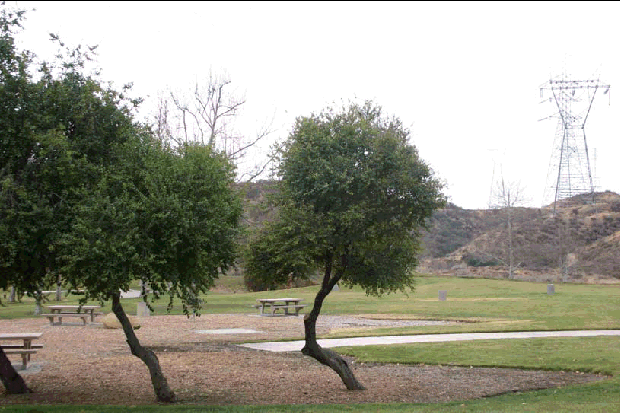
Figure 1.A
Mountain View Park on Seco Canyon Road is an example of an open space developed on a transmission line right-of-way.
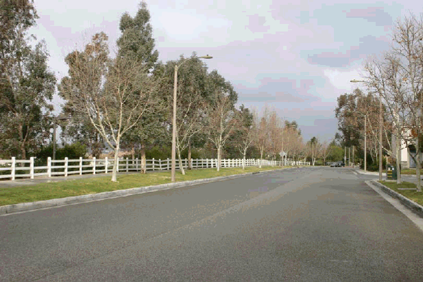
Figure 1.B
Tree planting along North Park Drive that screens views toward the nearby transmission corridor.
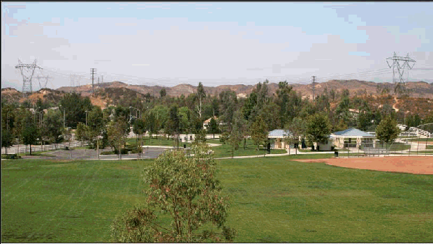
Figure 2.A
This is the EIR/EIS's existing condition view from KOP 13, which is described as the view from the North Park Elementary School
and Cheeseborough County Park.
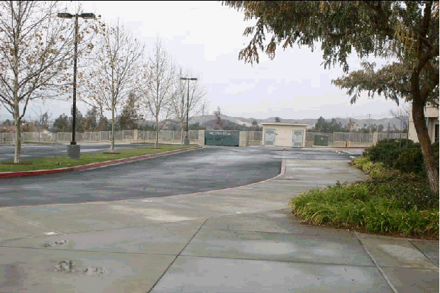
Figure 2.B
View from the area in front of the entrance to the North Park Elementary School. This view is more representative of the views toward the project alignment that would be experienced by viewers at the school than the view used in the EIR/EIS (Figure 2.A above), which represents the view of someone who would be standing at the fence at the far end of the parking lot and peering over.
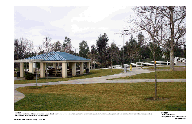
Figure 3.A
View looking west from one of the primary use areas in Cheeseborugh County Park. This view is more representative of the views toward the project alignment that would be experienced by park users than the view used in the EIR/EIS (Figure 2.A), which was taken from an elevated location outside the park.
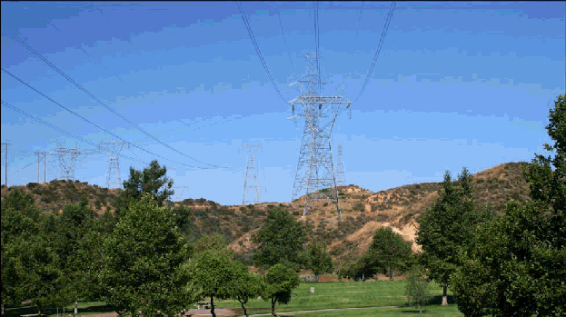
Figure 4.A
The EIR/EIS existing conditions view of the project alignment from KOP 11, Mountain View Park.
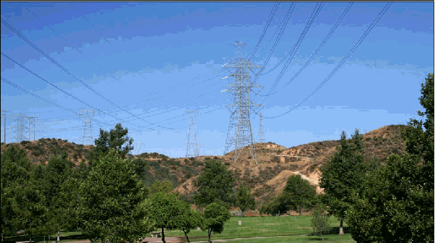
Figure 4.B
The EIR/EIS simulation of the proposed project as it would appear in the view from KOP 11, Mountain View Park. Review of the two
images makes it clear that although there is a change to the view, the effects on view character and quality are relatively subtle, and
that the EIR/EIS assessment that the level of visual change is high and significant is not warranted.
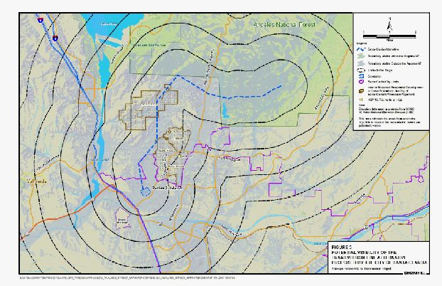
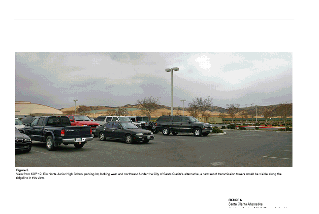
Figure 6.
View from KOP 12, Rio Norte Junior High School parking lot, looking west and northwest. Under the City of Santa Clarita's alternative, a new set of transmission towers would be visible along the ridgeline in this view.
1 Impact B-1: The Project would cause temporary or permanent loss of native vegetation communities.
2 Impact B-7: The proposed Project would result in the loss of listed plant species.
3 Impact B-3: The Project would cause loss of foraging habitat for wildlife.
4 Impact B-5: Construction activities and increased vehicular traffic on access roads would disturb wildlife species.
5 Impact B-29: The Project would affect linkages and wildlife movement corridors.
6 Impact B-12: The Project would result in the loss of coastal California gnatcatchers.
7 Impact B-8: Construction activities would result in the loss of arroyo toads.
8 Impact C-2: Destruction of P19-186857 would occur as a result of the Project.
9 Impact G-1: Excavation and grading during construction activities could cause slope instability.
10 Impact G-9: Transmission line structures could be damaged by landslides, earth flows, or debris slides.
11 Impact G-4: Transmission line damage by surface fault ruptures at crossings of active faults.
12 Impact G-5: Project structures could be damaged by landslides, liquefaction, settlement, lateral spreading, and/or surface cracking resulting from seismic events.
13 Impact G-3: Minor changes in topography due to excavation and grading.
14 Impact G-10: Excavation for transmission line structures could damage unique or significant fossils.
15 Impact H-1: Soil erosion and sedimentation caused by construction activities would degrade water quality.
16 Impact H-2: Degradation of surface water or groundwater quality would occur from the accidental release of potentially harmful materials during construction activities.
17 Impact L-1: Construction of the Project would temporarily disrupt existing residential and commercial land uses.
18 Impact L-4: Operation of the Project would cause long-term disruption of existing commercial land uses.
19 Impact R-1: Construction of the Project would preclude the use of established recreation areas in the Angeles National Forest and in the City of Santa Clarita.
20 Impact N-2: Operational corona noise levels at Veluzat Motion Picture Ranch would violate Los Angeles County standards.
21 Impact N-5: The Project would result in a permanent increase in ambient noise levels at Veluzat Motion Picture Ranch.
22 Impact N-7: Temporary increases in ambient noise levels would severely disrupt operations at Veluzat Motion Picture Ranch.
23 Impact PH-2: Project results in encountering known preexisting soil or groundwater contamination.
24 Impact PH-3: Project results in encountering unknown preexisting soil or groundwater contamination.
25 Impact PH-1: Soil or groundwater contamination results due to improper handling and/or storage of hazardous materials during construction activities.
26 Impact V-9: The Project would alter the visual quality of landscape views as seen from Veluzat Motion Picture Ranch (KOP 9).
27 Impact V-10: Project infrastructure would alter the visual quality of landscape views as seen from North High Ridge Drive (KOP 10).
28 Impact V-11: Project infrastructure would alter the visual quality of landscape views as seen from Mountain View Park (KOP 11).
29 Impact V-12: Project infrastructure would alter the visual quality of landscape views as seen from Rio Norte Junior High School (KOP 12).
30 Impact V-13: Project infrastructure would alter the visual quality of landscape views as seen from North Park Elementary School and Chesebrough Park (KOP 13).
31 Impact V-14: Project infrastructure would alter the visual quality of landscape views as seen from Copper Hill Road (KOP 14).

